


 HOME > About Us > Maps & Directions


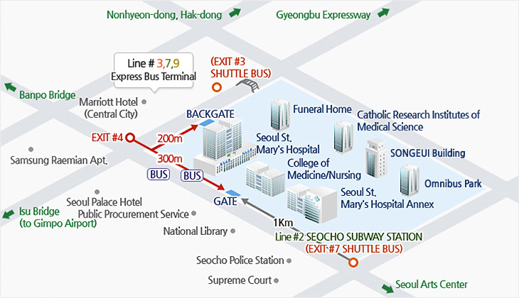
Automobile
| Gyeongbu Expressway |
Banpo IC(towards Express Bus Terminal)-first intersection-200 meters ahead-over underpass (Sapyeong Underpass)-a u-turn and 20 meters ahead - Seoul St. Mary's Hospital |
|---|---|
| Jungbu Expressway |
Dong-Suwon Tollgate-Olympic Highway to Gimpo-under Hannam Bridge(towards Gyeongbu Expressway)-towards the Express Bus Terminal on the right side of the road-past New Core Department Store-past the first intersection (in front of Express Bus Terminal) towards the intersection on a hill, turn right-200 meters ahead-over underpass (Sapyeong), u-turn and 20 meters ahead - Seoul St. Mary's Hospital |
| Seohaean Expressway |
Balan IC-towards Gwacheon-Namtaeryeong-turn right on Sadang Intersection-turn left on the three-way intersection in front of the Seoul Arts Center-past Seocho Police Station and 70 meters ahead(right) - Seoul St. Mary's Hospital |
| Uijeongbu/ Dongducheon/ Pocheon |
Dongbu Arterial Road-enter Olympic Highway from the end of Seongsu Bridge (towards Gimpo) -under Hannam Bridge (towards Gyeongbu Expressway)-towards Express Bus Terminal on the right side of the road-past New Core Department Store-past the first intersection (in front of Gangnam Express Bus Terminal) towards the intersection on a hill, turn right-200 meters ahead-make a u-turn over the underpass (Sapyeong) and 20 meters ahead - Seoul St. Mary's Hospital |
| Olympic Highway (from Gimpo) |
Gimpo Bridge-Yanghwa Bridge-past Banpo Bridge on the right side of the road-get on the overpass-past the intersection and 50 meters ahead - Seoul St. Mary's Hospital |
 Catholic University of Korea. All rights reserved.")